Osprey author, Myke Cole is on a research trip around Greece ahead of his upcoming book The Bronze Lie: Shattering the Myth of Spartan Warrior Supremacy. Read on to find out more about his next stop: Leuctra.
I’m writing this from the tiny mountain town of Vilia not far from the Leuctra battlefield, where I spent the day surveying the site of the Theban victory in 371 BC. At Leuctra, an outnumbered force led by Epaminondas (and featuring the famous Pelopidas at the head of the Theban Sacred Band) smashed the Spartan army under King Cleombrotus, making him the first Spartan king to be killed in battle since Leonidas fell at Thermopylae in 480 BC.
Unfortunately, there’s no Osprey campaign series book on Leuctra (I just made a quick note to get on that as soon as I have time), but we have a great source for the battle in Xenophon’s Hellenica. The actual site and course of the battle aren’t very well understood, and I wanted to lay down some thoughts on that here and share some pictures of my visit.
First – Xenophon tells us that King Cleombrotus approached the battlefield by a specific route (I’ll talk about that in a moment) and camped on a hill, and that the Thebans camped on another hill opposite the Spartans and not far away. We know that Cleombrotus didn’t want to fight (he had a long reputation of avoiding fights – which I discuss in my forthcoming book The Bronze Lie: Shattering the Myth of Spartan Warrior Supremacy), and he was warned by his advisors that failure to give battle might result in an accusation of being a friend to the Thebans and maybe a trial back home in Sparta.
Cleombrotus had good reason to be worried. In between the two hills was a wide Boeotian plain – good ground for cavalry, and the Thebans had cavalry superiority at Leuctra both in numbers and in skill. Epaminondas would have wanted the Spartans to come down into the plain where the cavalry would tell, and Cleombrotus, goaded on by the accusations of cowardice, gave the Theban exactly what he wanted.
We know the resulting cavalry duel was a major loss for the unskilled and outnumbered Spartan cavalry, who fled through the Spartan lines, badly disordering their heavy infantry and depriving them of critical cohesion before the lines engaged. We also know that Epaminondas introduced two signal innovations at Leuctra: 1) He massed his elite Sacred Band on the Theban left 50 ranks deep (the typical hoplite phalanx deployed around 8 ranks deep) and 2) he ‘refused’ his right flank, deploying his right in ‘echelon’, which means it slanted back away from the Spartans. This meant the Spartans had to cross more ground to reach the weaker Theban right, which turned the battle into a race – Epaminondas was betting his super-strong left would break the Spartan right (where King Cleombrotus was guarded by his hippeis royal guard) before the Spartans could reach and overpower the weaker Theban right.
The gamble paid off. Led by Pelopidas, the super-deep Theban Sacred Band punched a hole straight through the Spartan right, killing Cleombrotus and sending panic through the entire Spartan army. By the time the dust settled, 1,000 Spartans lay dead (4,000, if you follow Diodorus Siculus rather than Xenophon) and Thebes had inflicted a defeat on Sparta from which she would never recover. Leuctra, more than any other event in Sparta’s history, signalled the city’s end as a politically and militarily relevant power in the ancient world. It would experience a brief revival under its reformist king Cleomenes III, but would never again exert a serious force on the posture or policy of Ancient Greece.
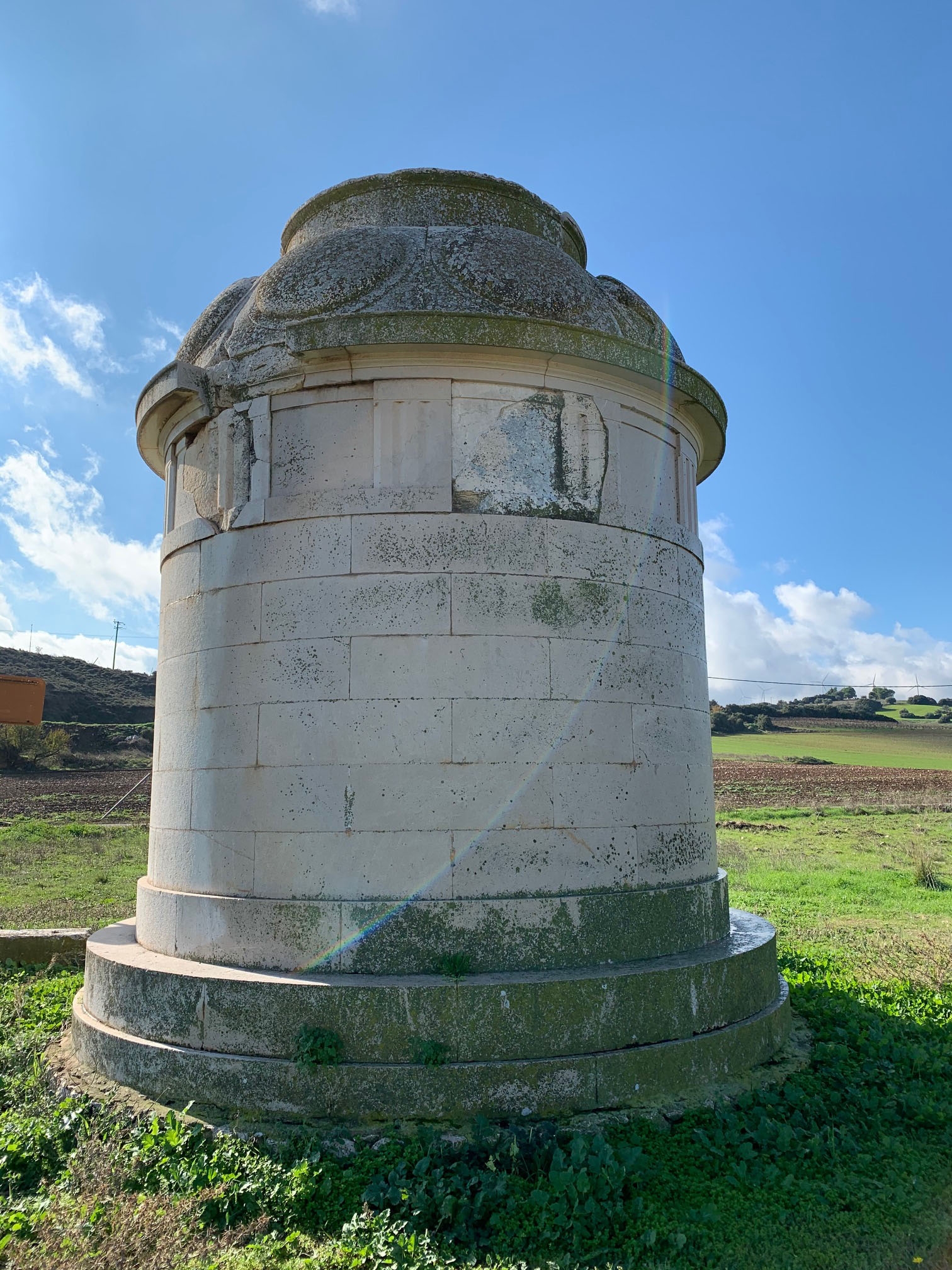
The Leuctra Tropaion (the Trophy or Monument of Leuctra) is a largely modern construction set at what I believe is the south end of the battlefield. Historian Scott Manning has a wonderful write-up of the history of the monument here. There are no signs directing you to it, and it’s in pretty much the middle of nowhere, so if you’re looking to find it, make sure you use the map included in Scott’s post. Neither the town of Leuctra nor the Tropaion are in Google Maps, but I can find them using Google Earth.

The Leuctra Tropaion
The Tropaion itself stands on the southern edge of the field, which is cut off by a huge irrigation canal. I don’t advise trying to hike the field anyway, it’s clearly privately owned farmland and you don’t want to get in trouble for trespassing.
View of the whole field from the southern rise
The interesting question is where the encampments of the respective armies were located, and I turned to Professor Michael Livingston (The Citadel) for help. Mike is a dear friend and mentor, and my co-star on the Discovery Channel show Contact, which just aired this past summer. Mike has built his career on being pretty much the greatest instinctive conflict geographer in the world. He has an innate ability to read maps, understand ground, examine imagery, and determine how battles played out.
Mike looked at the battlefield based on the position of the Tropaion. We’re pretty sure the Tropaion marks the battlefield, because a German classicist excavated portions of it on the site in 1839. The famous Roman Cicero complained of the decision to build a permanent monument there (he felt war memorials should be temporary). Mike’s analysis of the ground yielded two proposed encampment sites based on his reading of Xenophon. The next thing was to check that assumption. I believed the key was in Xenophon’s description of the march to Leuctra, found in Hellenica 6.4.3. Xenophon notes that Cleombrotus marched on Thebes from the west, moving through Thisbae, which is near the location of modern Thisvi. Xenophon then notes that Cleomobrotus took the fortress at Creusis. Pausanias and Strabo describe Creusis as being located at the head of a bay in the Corinthian Gulf, and just beside where Mount Cithaeron projects out into the sea. This makes the modern location most likely Paralia Livadostratas. From there, Cleombrotus could have travelled over the mountains to Leuctra (there is a relatively low point just south of the town), or followed the valley to the north of Cithaeron to modern day Kaparelli, where he would have doubled back to Leuctra, possibly because scouts brought word of Epaminondas and the Theban army approaching from the north-east, and Cleombrotus would not have wanted to be caught on the open plain when he knew the enemy had cavalry superiority.
However you slice it, this approach confirms Mike’s suspicion, and I confirmed it visually. There is only one truly high point in the vicinity of the Tropaion – directly to its south, where Cleombrotus may have camped before his advisors goaded him into seeking battle. About a mile north (across the irrigation canal), I could see another rise, much lower, but still high enough to give a commanding view. This is a possible location for the Theban camp – they wouldn’t have cared about much of a rise, as they wanted to fight in the lowlands where their cavalry could be brought to bear.
The rise to the south of the field - a possible location for the Spartan camp
The rise to the north of the field (cut off by an irrigation canal) - a possible location for the Theban camp
I’ll be working to further confirm Mike’s suspicions and will provide greater detail on the battle in The Bronze Lie. For now, I’m going to grab dinner and prepare to head south to Laconia tomorrow – there to survey the battlefield at Sellasia (another of Mike’s suggested locations, and a very compelling one) where the Spartan king Cleomenes III fought the Antigonids under Antigonus III Doson in 222 BC.
Follow Myke Cole here:
If you're following along with Myke, catch up on his last blog posts here:
Entry #1: Visiting Thermopylae with Myke Cole (#1)


Comments
You must be logged in to comment on this post. Click here to log in.
Submit your comment