Today is the 75th Anniversary of the D-Day landings. To commemorate this anniversary of the landings, we look at the key assaults that occurred that day using a few extracts from Steven Zaloga’s Atlas of the European Campaigns 1944-45.
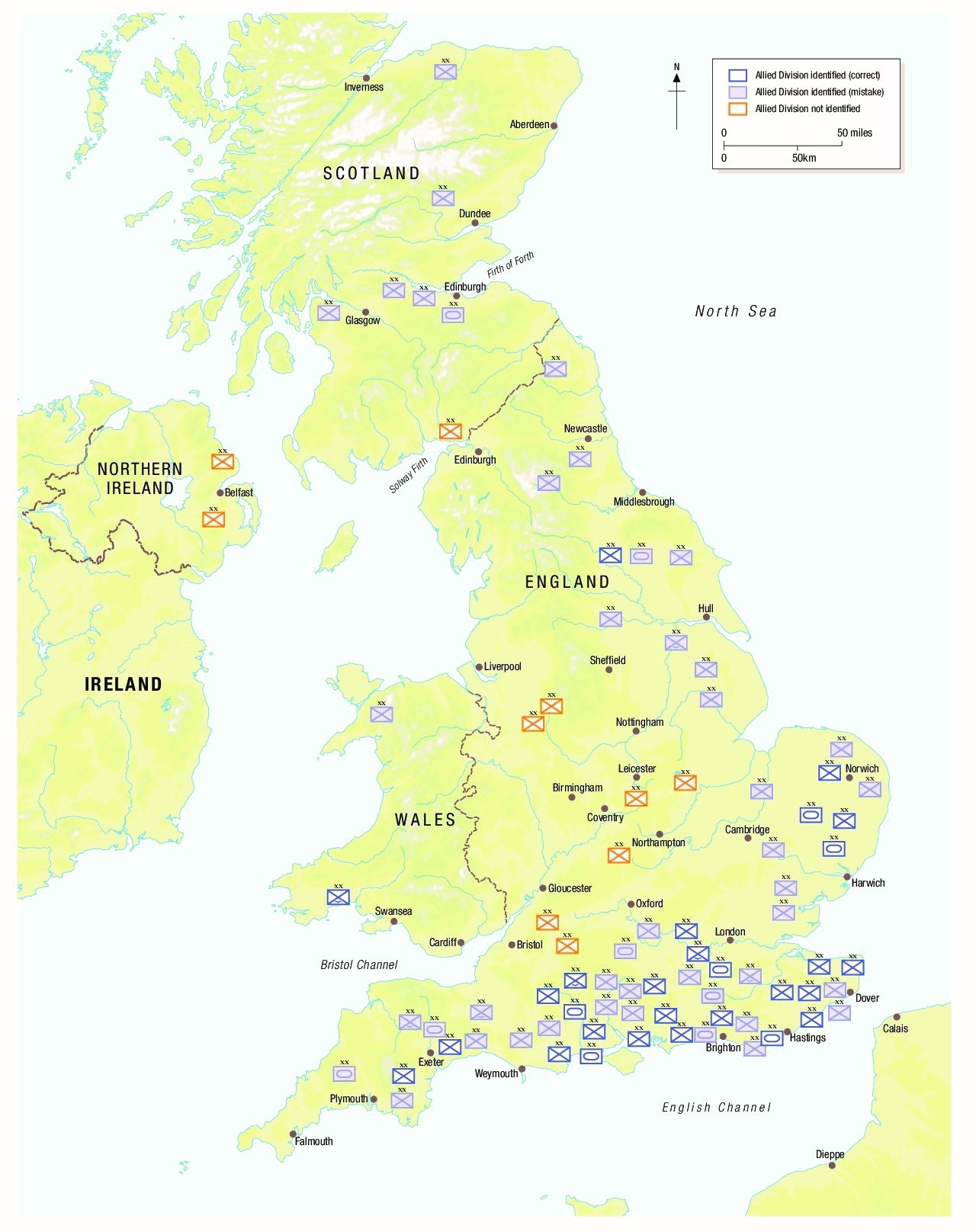
This blog post examines the German assessment of Allied divisions in the UK prior to D-Day.
"This map shows the German appreciations of the Allied forces in the UK compiled by the army intelligence agency Fremde Heere West (FHW – Foreign Armies West) for May 31, 1944, the last such assessment prior to the D-Day invasion. Besides the divisions shown on the map, FHW assumed there were a further three infantry divisions, two armored divisions, and one airborne division for which the location was unidentified but presumed to be in southern England. In total, the FHW assessment tallied 79 Allied divisions (56 infantry, 15 armored, and 8 airborne) as well as 20 separate infantry, armored, and airborne brigades. In reality, this was a substantial overestimate. Actual Allied strength in the UK at the time was closer to 38 divisions (28 infantry, 6 armored, and 4 airborne) with the caveat that numerous US and Canadian divisions were arriving continually during this period. The FHW correctly identified the locations of about 27 of the 38 actual Allied divisions, and missed the locations of the remainder. In addition, they counted over 40 “ghost” divisions.
The overestimate was due to a number of factors. German intelligence networks in Britain had been compromised by British counterintelligence. Operation Bodyguard was a coordinated deception program, feeding false information to turned German agents, using fake radio networks to create a fictional order of battle, and creating dummy garrisons and port installations to fool German aerial reconnaissance. These actions were based on false invasion scenarios such as operations Fortitude North (amphibious landings in Norway, to tie down the 400,000 German troops there), Fortitude South (the Pas-de-Calais) and Ironside (the Bay of Biscay) to shield the actual landing plans in Normandy. Numerous Allied “ghost” divisions were part of the bluff. Berlin remained convinced well into August 1944 that Normandy was only the first of potentially several Allied amphibious operations using the numerous divisions assumed to be in Britain.
The FHW had no reliable method of comparing its assessments using other technical means. Owing to Allied air superiority over the UK, Luftwaffe photo-intelligence missions were not numerous enough to create an up-to-date aerial overview of military garrisons in the UK. Other traditional intelligence methods such as signals intelligence were not entirely useful. The Allied deception plans included radio transmissions from fake Allied ghost divisions, and actual divisions could limit their transmissions since landlines were available. Prisoner-of-war interrogations were of limited utility since the source of recent prisoners, mainly from Italy, had little or dated information about forces back in the UK. Aside from the difficulties of assessing the Allied order of battle, Berlin faced the dilemma of determining where and when the Allies would stage their main amphibious operation. The issue of “when” was perhaps the easiest to answer. It seemed apparent that an Allied landing would occur in the late spring or early summer of 1944. Determining the precise date proved elusive, largely owing to the Allied deception effort. Too many dates were offered by too many intelligence sources, essentially clouding the issue. The issue of “where” was a greater dilemma. Assessments through spring 1944 tended to place the landing site somewhere on the Pas-de-Calais since this was the narrowest section of the English Channel and offered the shortest route to Germany. This was reflected in the disposition of Wehrmacht units in France, as well as the construction of the Atlantic Wall. There was always a stipulation in these assessments that the landings might occur elsewhere, including on the Belgian or Dutch coasts, or even Brittany or the Bay of Biscay. This confusion was reflected in the dispersion of the Atlantic Wall defenses.
The Marinegruppenkommando (MGK) West (Naval Group Command West) began changing its assessment in the months prior to D-Day. The MGK West reacted skeptically to agent reports claiming a concentration of Allied shipping in the southeast of England, correctly judging that the majority was in fact in the Portsmouth area or to the immediate west. The MGK West assessments from April 26 and May 2, 1944 both suggested that the Allied landings might occur from the Somme all the way west to the Cotentin Peninsula. Assessments of Allied transport capability were poor, with little firm evidence of the number of critical landing ships, especially the LST. The MGK West believed that the Allies could deliver about eight divisions with conventional assault ships, but the number would expand to 13 divisions if the Allies had 120 LSTs available and 17.4 divisions if they had 220 LSTs. Luftwaffe assessments in the pre-invasion months also hinted at a more westerly landing site. The Luftwaffe noted that the Allies seemed to be trying to isolate the future Normandy battlefield by attacks against the Seine bridges. Strikes against bridges across the Loire at Angers, Tours, and Orléans all pointed to an effort to isolate the Normandy region. In the event, neither the Kreigsmarine nor Luftwaffe intelligence estimates held much sway in Berlin or in the Oberbefehlshaber (OB) West (High Command West) headquarters in France."
- Steven Zaloga, Atlas of the European Campaigns 1944-45, page 18
To find out more about D-Day, head to the blog and order your copy of Atlas of the European Campaigns 1944-45.


Comments
You must be logged in to comment on this post. Click here to log in.
Submit your comment